Hi Tony,
No matter how devoid of details the terrain map from Google is, it does give a few insights.
It appears that the blue area has the least steep slopes, so I would personally check that area first, especially to see if it would work for gardens. Walking up and down slopes costs an awful lot of energy, so the more you can minimize that on areas that are visited often, the better.
Also with the color markings you identify areas covering the entire slope from top to bottom. I would suggest to look at all of your terrain according to where the contour lines bring you. A horizontal walk from south to north, following the contour line is almost effortless, while climbing up and and going down is way harder. Focus on areas which are easiest to reach and have the least slope for anything important that requires your attention, basically zone 1 and 2. If you plan on having animals, see if they can be placed in areas that are more difficult for you to work on.
I'm looking forward to a more detailed map later. You've got a challenging and therefore interesting property there.


![[Thumbnail for IMG_20161222_112152.JPG]](/t/61200/a/46052/IMG_20161222_112152.JPG "Filename: IMG_20161222_112152.JPG
Description:")
![[Thumbnail for IMG_20161223_123728.JPG]](/t/61200/a/46053/IMG_20161223_123728.JPG "Filename: IMG_20161223_123728.JPG
Description:")
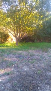
 we will be using the area to grow in but the majority of that area will have to be used for our infrastructure. The small clean spring and the stone shed are there so it makes sense to build everything else around them. The left hand side of the blue area is also sheltered by some mature trees on the neighbours land so it doesn't get as much sunlight as the yellow area, which gets sun all day long.
 ![[Thumbnail for IMG_20161224_154059.JPG]](/t/61200/a/46090/IMG_20161224_154059.JPG "Filename: IMG_20161224_154059.JPG
Description:")